The piece of text below is a shortened, hashed representation of this content. It is useful to ensure the content has not been tampered with, as a single modification would result in a totally different value.
Value:
42c347ebf396a6e6da9da635d23e8fbd8e9d46bd456df3450d3bd53ac14451d3
Source:
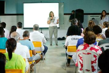
{"body":{"en":"\n<p>The Neighborhood Plan as a methodology was initiated in 2020 by request of the Social Work of Sister Dulce, a local religious organization, to the Salvador City Hall, through the Fundação Mário Leal Ferreira (FMLF). The request was to support the Holy Territory project, whose objective was to encourage religious tourism in the Itapagipe peninsula as a way to improve the conditions of the territory to receive pilgrims.</p>\n<div class=\"editor-content-image\" data-image=\"\"><img src=\"/rails/active_storage/blobs/redirect/eyJfcmFpbHMiOnsibWVzc2FnZSI6IkJBaHBBbWt6IiwiZXhwIjpudWxsLCJwdXIiOiJibG9iX2lkIn19--229a6e66fc5481189a3fb6e08255771bbfa8415e/657b93bdf7a27c6c6a4273645623e155\" alt=\"\"></div>\n<p><br></p>\n<p>The peninsula is part of the city and comprises 14 neighborhoods, where 164,264 inhabitants live (CENSUS 2010), having its history defined by the city's own history and by the faith in three saints: Saint Dulce de los Pobres, Saint John Paul II and Mother Teresa of Calcutta. It also highlights the pilgrimage to the Church of Senhor do Bomfim, the largest ecumenical devotion of Salvador (Catholic and Candomblé). It was the location of the city's former garbage dump, an area of the city known as Alagados, which was transferred in the 1980s to the Canabrava neighborhood, but is still mostly occupied today by vulnerable population. </p>\n<p>Thus, the FMLF decided to elaborate an urban diagnosis that showed that the needs of the territory required a multisectoral, transdisciplinary approach and a broad participatory process involving leaders, local organizations, universities and other municipal departments.</p>\n<p>At the same time, FMLF technicians elaborated the diagnosis of the peninsula to initiate the collective construction, carried out in virtual workshops and with a broader public consultation. At that time, Covid 19's health crisis prevented face-to-face meetings.</p>\n<p>All the technical content produced was submitted to the appreciation, complementation and validation of the participants and the planning was built in a participatory manner, generating thematic maps with proposed actions, goals and execution deadlines. As emergency actions were identified, they were prioritized.</p>\n<p>Based on this experience, the Ilha de Maré Neighborhood Plan was subsequently developed and the Canabrava Plan is currently being finalized. Another plan is scheduled to be launched in 2023.</p>\n<div class=\"editor-content-image\" data-image=\"\"><img src=\"/rails/active_storage/blobs/redirect/eyJfcmFpbHMiOnsibWVzc2FnZSI6IkJBaHBBbW96IiwiZXhwIjpudWxsLCJwdXIiOiJibG9iX2lkIn19--d1ea7eb5e44efd11e98323dcb81abe7349a58818/172168649698b80f55b9ad002b9bd842\" alt=\"\"></div>\n<p><br></p>\n<p>The three plans mentioned above cover 16 neighborhoods in which 182,164 people live, or 7% of Salvador's population.</p>\n<p>The second plan, for the island of Maré, was concluded in 2023. Being one of the city's islands, it has 4,326 residents in 12 communities. It is a quilombola territory, with 4 of the 5 quilombos recognized by the Palmares Foundation in Salvador, and presents problems of internal mobility and connection with the mainland. </p>\n<p>The third plan is scheduled for completion in August of this year, and is serving as the basis for defining the international support of the Gap Fund in Salvador. This is a neighborhood of 13,664 inhabitants, located in the center of the city and formed after the relocation of the Alagados landfill, by the landfill's waste pickers.</p>\n<p>The methodology is being developed and refined as new plans are developed. The assessment is scheduled to take place in 2 years, 4 years and 8 years after publication.</p>\n<p>The first assessment, that of Itapagipe, is scheduled for 2024, which will undoubtedly contribute to planning.</p>\n<p><br></p>\n<p><br></p>\n<p>Site da Fundação: <a href=\"https://fmlf.salvador.ba.gov.br/\" target=\"_blank\">https://fmlf.salvador.ba.gov.br/</a> </p>\n<p>Plano de Bairro de Itapagipe: <a href=\"http://biblioteca.fmlf.salvador.ba.gov.br/phl82/pdf/livros/Plano_Itapagipe.pdf\" target=\"_blank\">http://biblioteca.fmlf.salvador.ba.gov.br/phl82/pdf/livros/Plano_Itapagipe.pdf</a></p>\n<p>Plano de Bairro de Ilha de Maré: <a href=\"http://biblioteca.fmlf.salvador.ba.gov.br/phl82/pdf/livros/Plano_Ilha_Mare.pdf\" target=\"_blank\">http://biblioteca.fmlf.salvador.ba.gov.br/phl82/pdf/livros/Plano_Ilha_Mare.pdf</a> </p>\n<p>Documentação completa do Plano da Ilha de Maré: <a href=\"https://fmlf.salvador.ba.gov.br/plano-da-ilha-de-mare/\" target=\"_blank\">https://fmlf.salvador.ba.gov.br/plano-da-ilha-de-mare/</a></p>\n<p>Documentação completa do Plano de Canabrava: <a href=\"https://fmlf.salvador.ba.gov.br/plano-de-bairro-de-canabrava/\" target=\"_blank\">https://fmlf.salvador.ba.gov.br/plano-de-bairro-de-canabrava/</a></p>\n\n","es":"\n<p>El Plan de Barrios como metodología se inició en 2020 por solicitud de la Obra Social de la Hermana Dulce, organización religiosa local, al Ayuntamiento de Salvador, a través de la Fundação Mário Leal Ferreira (FMLF). La solicitud era para apoyar el proyecto Territorio Santo, cuyo objetivo era incentivar el turismo religioso en la península de Itapagipe como forma de mejorar las condiciones del territorio para recibir peregrinos.</p>\n<div class=\"editor-content-image\" data-image=\"\"><img src=\"/rails/active_storage/blobs/redirect/eyJfcmFpbHMiOnsibWVzc2FnZSI6IkJBaHBBbXN6IiwiZXhwIjpudWxsLCJwdXIiOiJibG9iX2lkIn19--f22d8e9264835f04b876490f64baebe06d24c777/0f27bcd5f444f04a8b0936b9b9b5f274\" alt=\"\"></div>\n<p>La península forma parte de la ciudad y abarca 14 barrios, donde viven 164.264 habitantes (CENSO 2010), teniendo su historia definida por la propia historia de la ciudad y por la fe en tres santos: Santa Dulce de los Pobres, San Juan Pablo II y la Madre Teresa de Calcuta. Destaca también la peregrinación a la Iglesia do Senhor do Bomfim, la mayor devoción ecuménica de Salvador (católica y candomblé). Fue la ubicación del antiguo basurero de la ciudad, una zona de la ciudad conocida como Alagados, que fue transferida en los años 80 al barrio de Canabrava, pero que aún hoy está ocupada en su mayoría por población vulnerable. </p>\n<p>Así, el FMLF decidió elaborar un diagnóstico urbano que demostró que las necesidades del territorio requerían un enfoque multisectorial, transdisciplinar y un amplio proceso participativo que implicase a líderes, organizaciones locales, universidades y otros departamentos municipales.</p>\n<p>Paralelamente, los técnicos del FMLF elaboraron el diagnóstico de la península para iniciar la construcción colectiva, realizada en talleres virtuales y con una consulta pública más amplia. En aquel momento, la crisis de salud de Covid 19 impidió las reuniones presenciales.</p>\n<p>Todo el contenido técnico producido fue sometido a la apreciación, complementación y validación de los participantes y la planificación se fue construyendo de forma participativa, generando mapas temáticos con propuestas de acciones, metas y plazos de ejecución. A medida que se identificaban las acciones de emergencia, se priorizaban.</p>\n<p>A partir de esta experiencia, se elaboró posteriormente el Plan de Barrios de Ilha de Maré y actualmente se está ultimando el Plan de Canabrava. Para 2023 está previsto iniciar otro plan.</p>\n<p>Los tres planes mencionados abarcan 16 barrios en los que viven 182.164 personas, es decir, el 7% de la población de Salvador.</p>\n<p><br></p>\n<div class=\"editor-content-image\" data-image=\"\"><img src=\"/rails/active_storage/blobs/redirect/eyJfcmFpbHMiOnsibWVzc2FnZSI6IkJBaHBBbXd6IiwiZXhwIjpudWxsLCJwdXIiOiJibG9iX2lkIn19--0c03a61c473d5de33219278f122b34d25c3d699d/70aa11908b657980c7a8f2577bfa2df0\" alt=\"\"></div>\n<p><br></p>\n<p>El segundo plan, para la isla de Maré, se concluyó en 2023. Siendo una de las islas de la ciudad, cuenta con 4.326 residentes en 12 comunidades. Es un territorio quilombola, con 4 de los 5 quilombos reconocidos por la Fundación Palmares en Salvador, y presenta problemas de movilidad interna y conexión con el continente. </p>\n<p>El tercer plan está previsto que concluya en agosto de este año, y está sirviendo de base para definir el apoyo internacional del Fondo Gap en Salvador. Se trata de un barrio de 13.664 habitantes, situado en el centro de la ciudad y que se formó tras el traslado del vertedero de Alagados, por los recicladores del vertedero.</p>\n<p>La metodología se está desarrollando y perfeccionando a medida que se elaboran los nuevos planes. Está previsto que la evaluación se realice dentro de 2 años, 4 años y 8 años después de su publicación.</p>\n<p>La primera evaluación, la de Itapagipe, está prevista para 2024, lo que sin duda contribuirá a la planificación.</p>\n<p><br></p>\n<p>Site da Fundação: <a href=\"https://fmlf.salvador.ba.gov.br/\" target=\"_blank\">https://fmlf.salvador.ba.gov.br/</a> </p>\n<p>Plano de Bairro de Itapagipe: <a href=\"http://biblioteca.fmlf.salvador.ba.gov.br/phl82/pdf/livros/Plano_Itapagipe.pdf\" target=\"_blank\">http://biblioteca.fmlf.salvador.ba.gov.br/phl82/pdf/livros/Plano_Itapagipe.pdf</a></p>\n<p>Plano de Bairro de Ilha de Maré: <a href=\"http://biblioteca.fmlf.salvador.ba.gov.br/phl82/pdf/livros/Plano_Ilha_Mare.pdf\" target=\"_blank\">http://biblioteca.fmlf.salvador.ba.gov.br/phl82/pdf/livros/Plano_Ilha_Mare.pdf</a> </p>\n<p>Documentação completa do Plano da Ilha de Maré: <a href=\"https://fmlf.salvador.ba.gov.br/plano-da-ilha-de-mare/\" target=\"_blank\">https://fmlf.salvador.ba.gov.br/plano-da-ilha-de-mare/</a></p>\n<p>Documentação completa do Plano de Canabrava: <a href=\"https://fmlf.salvador.ba.gov.br/plano-de-bairro-de-canabrava/\" target=\"_blank\">https://fmlf.salvador.ba.gov.br/plano-de-bairro-de-canabrava/</a> </p>\n\n","fr":"\n<p>Le plan de quartier en tant que méthodologie a été initié en 2020 à la demande de l'Œuvre sociale de Sœur Dulce, une organisation religieuse locale, au conseil municipal de Salvador, par l'intermédiaire de la Fundação Mário Leal Ferreira (FMLF). La demande visait à soutenir le projet Territoire Saint, dont l'objectif était d'encourager le tourisme religieux dans la péninsule d'Itapagipe afin d'améliorer les conditions d'accueil des pèlerins sur le territoire.</p>\n<div class=\"editor-content-image\" data-image=\"\"><img src=\"/rails/active_storage/blobs/redirect/eyJfcmFpbHMiOnsibWVzc2FnZSI6IkJBaHBBbTB6IiwiZXhwIjpudWxsLCJwdXIiOiJibG9iX2lkIn19--c40666fd8102961c490253d2572b7f109e2953e5/d5dd35c023e84320d28a7c2e802e5a4b\" alt=\"\"></div>\n<p>La péninsule fait partie de la ville et comprend 14 quartiers, où vivent 164 264 habitants (CENSUS 2010). Son histoire est définie par l'histoire de la ville elle-même et par la foi en trois saints : Sainte Dulce de los Pobres, Saint Jean-Paul II et Mère Teresa de Calcutta. Le pèlerinage à l'église du Senhor do Bomfim, la plus grande dévotion œcuménique de Salvador (catholique et candomblé), mérite également d'être mentionné. C'est là que se trouvait l'ancienne décharge de la ville, une zone de la ville connue sous le nom d'Alagados, qui a été transférée dans les années 1980 dans le quartier de Canabrava, mais qui est toujours occupée en grande partie par des populations vulnérables. </p>\n<p>La FMLF a donc décidé d'élaborer un diagnostic urbain qui a montré que les besoins du territoire nécessitaient une approche multisectorielle, transdisciplinaire et un large processus participatif impliquant les dirigeants, les organisations locales, les universités et les autres services municipaux.</p>\n<p>Parallèlement, les techniciens de la FMLF ont élaboré le diagnostic de la péninsule pour initier la construction collective, réalisée en ateliers virtuels et avec une consultation publique élargie. A l'époque, la crise sanitaire de Covid 19 n'a pas permis d'organiser des réunions en face à face.</p>\n<p>Tous les contenus techniques produits ont été soumis à l'appréciation, à la complémentation et à la validation des participants et la planification a été construite de manière participative, générant des cartes thématiques avec des propositions d'actions, des objectifs et des délais d'exécution. Au fur et à mesure que les actions d'urgence ont été identifiées, elles ont été classées par ordre de priorité.</p>\n<p>Sur la base de cette expérience, le plan de quartier de Ilha de Maré a été développé par la suite et le plan de Canabrava est actuellement en cours de finalisation. Un autre plan devrait être lancé d'ici 2023.</p>\n<p>Les trois plans mentionnés ci-dessus couvrent 16 quartiers où vivent 182 164 personnes, soit 7 % de la population de Salvador.</p>\n<p><br></p>\n<div class=\"editor-content-image\" data-image=\"\"><img src=\"/rails/active_storage/blobs/redirect/eyJfcmFpbHMiOnsibWVzc2FnZSI6IkJBaHBBbTR6IiwiZXhwIjpudWxsLCJwdXIiOiJibG9iX2lkIn19--492f30da10161bb71156244d3649c11e0a125aea/fbe342f910038f75060ecfc348f8529a\" alt=\"\"></div>\n<p><br></p>\n<p>Le deuxième plan, pour l'île de Maré, a été achevé en 2023. Il s'agit d'une des îles de la ville qui compte 4 326 habitants répartis dans 12 communautés. C'est un territoire de quilombos, avec 4 des 5 quilombos reconnus par la Fondation Palmares à Salvador, qui présente des problèmes de mobilité interne et de connexion avec le continent. </p>\n<p>Le troisième plan devrait être achevé en août de cette année et sert de base à la définition du soutien international du Gap Fund à Salvador. Il s'agit d'un quartier de 13 664 habitants, situé au centre de la ville, qui a été créé après le déplacement de la décharge d'Alagados, par les ramasseurs de déchets de la décharge.</p>\n<p>La première évaluation, celle d'Itapagipe, est prévue pour 2024, ce qui contribuera sans aucun doute à la planification.</p>\n<p><br></p>\n<p>Site da Fundação: <a href=\"https://fmlf.salvador.ba.gov.br/\" target=\"_blank\">https://fmlf.salvador.ba.gov.br/</a> </p>\n<p>Plano de Bairro de Itapagipe: <a href=\"http://biblioteca.fmlf.salvador.ba.gov.br/phl82/pdf/livros/Plano_Itapagipe.pdf\" target=\"_blank\">http://biblioteca.fmlf.salvador.ba.gov.br/phl82/pdf/livros/Plano_Itapagipe.pdf</a></p>\n<p>Plano de Bairro de Ilha de Maré: <a href=\"http://biblioteca.fmlf.salvador.ba.gov.br/phl82/pdf/livros/Plano_Ilha_Mare.pdf\" target=\"_blank\">http://biblioteca.fmlf.salvador.ba.gov.br/phl82/pdf/livros/Plano_Ilha_Mare.pdf</a> </p>\n<p>Documentação completa do Plano da Ilha de Maré: <a href=\"https://fmlf.salvador.ba.gov.br/plano-da-ilha-de-mare/\" target=\"_blank\">https://fmlf.salvador.ba.gov.br/plano-da-ilha-de-mare/</a></p>\n<p>Documentação completa do Plano de Canabrava: <a href=\"https://fmlf.salvador.ba.gov.br/plano-de-bairro-de-canabrava/\" target=\"_blank\">https://fmlf.salvador.ba.gov.br/plano-de-bairro-de-canabrava/</a></p>\n\n"},"title":{"en":"Salvador Neighborhood Plans","es":"Planes de Barrio de Salvador","fr":"Plans de quartier de Salvador"}}
This fingerprint is calculated using a SHA256 hashing algorithm. In order to replicate it yourself, you can use an MD5 calculator online and copy-paste the source data.


Share
Or copy link