The piece of text below is a shortened, hashed representation of this content. It is useful to ensure the content has not been tampered with, as a single modification would result in a totally different value.
Value:
786fc0dcfc5f290986bccc39598f174d3dfcc51b8f5360d4a1f25bced39459e1
Source:
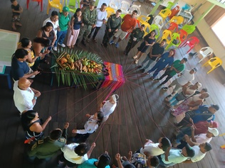
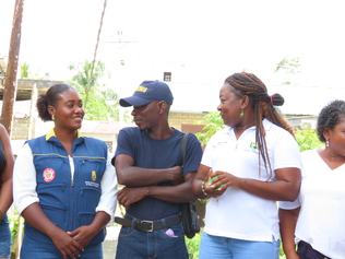
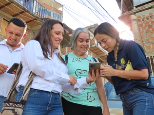
{"body":{"en":"<p>The Community Maps for Disaster Risk Management in Colombia constitute an institutional strategy designed to formally integrate communities’ territorial knowledge into local public decision-making. Since 2023, the initiative has addressed a specific gap: official risk information did not systematically incorporate community knowledge, limiting the legitimacy and effectiveness of municipal planning.</p><p>The project aims to strengthen both technical and alternative capacities within communities to identify and analyze risk scenarios; to build and validate geospatial information through participatory and collaborative cartography; and to incorporate these results into municipal risk management and territorial planning instruments, ensuring real influence on the prioritization of actions and investments. The methodology, defined in the project’s official guide, is structured in five clear and sequential phases.</p><p>To date, 4,092 people have actively participated in the process. This reach represents not only coverage but also a concrete expansion of the local democratic base. Communities have shifted from being merely consulted actors to becoming producers of technical information that directly influences public management. The institutional validation of their contributions has strengthened transparency, reduced discretion in prioritizing interventions, and improved the quality of decision-making.</p><p>The experience developed in the Community Council of Sivirú-Dotenedó, in the municipality of Bajo Baudó (Chocó), represents an emblematic case of how participatory and collaborative cartography can strengthen territorial democracy in Black and Afro-descendant communities that have historically been excluded from formal planning processes.</p><p>In territories marked by histories of exclusion, inequality, or conflict, the methodology has created formal spaces for dialogue between the State and citizens, reducing tensions related to territorial governance and promoting shared responsibility. By institutionalizing participation and transforming it into binding technical input, the Community Maps initiative not only strengthens disaster risk management but also expands local democracy and contributes concretely to territorial peacebuilding by fostering trust, inclusion, and evidence-based, shared decision-making grounded in territorial knowledge.</p><p>Learn more:<a href=\"https://sites.google.com/gestiondelriesgo.gov.co/mapascomunitarios/\"> <u>https://sites.google.com/gestiondelriesgo.gov.co/mapascomunitarios/</u></a></p><p><a href=\"https://sites.google.com/gestiondelriesgo.gov.co/mapascomunitarios/\"><u>https://www.oidp.net/docs/repo/doc1825.pdf</u></a></p><p><a href=\"https://sites.google.com/gestiondelriesgo.gov.co/mapascomunitarios/\"><u>https://www.oidp.net/docs/repo/doc1845.pdf</u></a><u> </u></p><p><a href=\"https://sites.google.com/gestiondelriesgo.gov.co/mapascomunitarios/\"><u>https://www.oidp.net/docs/repo/doc1846.pdf</u></a></p><p><br></p><div class=\"editor-content-videoEmbed\" data-video-embed=\"https://youtu.be/vgMGD7A7ztE\"><div><iframe src=\"https://www.youtube-nocookie.com/embed/vgMGD7A7ztE\" title=\"Colombia and Municipalities: Community Maps for Disaster Risk Management – A Commitment to Building Democracy through Participatory Cartography in Colombian Territories\" frameborder=\"0\" allowfullscreen=\"true\"></iframe></div></div>","es":"<p><br>Los Mapas Comunitarios de Gestión del Riesgo de Desastres en Colombia consistieron en una estrategia institucional diseñada para integrar de manera formal el conocimiento territorial de las comunidades en la toma de decisiones públicas locales. Desde 2023, la iniciativa responde a una brecha concreta: la información oficial sobre riesgo no incorporaba sistemáticamente el conocimiento comunitario, lo que limitaba la legitimidad y efectividad de la planificación municipal.</p><p>El proyecto organizacional tuvo como objetivos fortalecer las capacidades técnicas y alternativas de las comunidades para identificar y analizar escenarios de riesgo; construir y validar información geoespacial mediante cartografía participativa y colaborativa; e incorpora estos resultados en los instrumentos municipales de gestión del riesgo y planificación territorial, garantizando incidencia real en la priorización de acciones e inversiones. La metodología, definida en la cartilla oficial del proyecto, se desarrolla en cinco fases claras y secuenciales. </p><p>A la fecha, 4.092 personas han participado activamente en este proceso. Este alcance no solo representa cobertura, sino ampliación concreta de la base democrática local. Las comunidades dejaron de ser actores consultados para convertirse en productores de información técnica que inciden en la gestión pública. La validación institucional de sus aportes fortaleció la transparencia, redujo la discrecionalidad en la priorización de intervenciones y mejoró la calidad de la toma de decisiones.</p><p>La experiencia desarrollada en el Consejo Comunitario de Sivirú-Dotenedó, en el municipio de Bajo Baudó (Chocó), representa un caso emblemático de cómo la cartografía participativa y colaborativa puede fortalecer la democracia territorial en comunidades negras y afrodescendientes históricamente excluidas de los procesos formales de planificación.</p><p>En territorios con antecedentes de exclusión, desigualdad o conflictividad, la metodología generó espacios formales de diálogo entre Estado y ciudadanía, disminuyendo tensiones asociadas a la gestión del territorio y promoviendo corresponsabilidad. Alizar la participación institucional y convertirla en insumo técnico vinculante, los Mapas Comunitarios no solo fortalecen la gestión del riesgo, sino que amplían la democracia local y contribuyentes de manera concreta a la construcción de paz territorial, al generar confianza, inclusión y decisiones compartidas basadas en evidencia y conocimiento territorial.</p><p>Conocer más: <a href=\"https://sites.google.com/gestiondelriesgo.gov.co/mapascomunitarios/\"><u>https://sites.google.com/gestiondelriesgo.gov.co/mapascomunitarios/</u></a> </p><p><a href=\"https://sites.google.com/gestiondelriesgo.gov.co/mapascomunitarios/\"><u>https://www.oidp.net/docs/repo/doc1825.pdf</u></a> </p><p><a href=\"https://sites.google.com/gestiondelriesgo.gov.co/mapascomunitarios/\"><u>https://www.oidp.net/docs/repo/doc1845.pdf</u></a> </p><p><a href=\"https://sites.google.com/gestiondelriesgo.gov.co/mapascomunitarios/\"><u>https://www.oidp.net/docs/repo/doc1846.pdf</u></a> </p><p><br></p><div class=\"editor-content-videoEmbed\" data-video-embed=\"https://youtu.be/vgMGD7A7ztE\"><div><iframe src=\"https://www.youtube-nocookie.com/embed/vgMGD7A7ztE\" title=\"Colombia and Municipalities: Community Maps for Disaster Risk Management – A Commitment to Building Democracy through Participatory Cartography in Colombian Territories\" frameborder=\"0\" allowfullscreen=\"true\"></iframe></div></div>","fr":"<p>Les Cartes communautaires de gestion des risques de catastrophes en Colombie constituent une stratégie institutionnelle conçue pour intégrer formellement les connaissances territoriales des communautés dans la prise de décision publique locale. Depuis 2023, l’initiative répond à un déficit concret : les informations officielles sur les risques n’intégraient pas systématiquement les savoirs communautaires, ce qui limitait la légitimité et l’efficacité de la planification municipale.</p><p>Le projet vise à renforcer les capacités techniques et alternatives des communautés pour identifier et analyser les scénarios de risque ; à produire et valider des informations géospatiales au moyen d’une cartographie participative et collaborative ; et à intégrer ces résultats dans les instruments municipaux de gestion des risques et de planification territoriale, garantissant ainsi une réelle incidence sur la priorisation des actions et des investissements. La méthodologie, définie dans le guide officiel du projet, se déploie en cinq phases claires et séquentielles.</p><p>À ce jour, 4 092 personnes ont participé activement au processus. Cette portée ne représente pas seulement une couverture territoriale, mais un élargissement concret de la base démocratique locale. Les communautés ne sont plus seulement consultées : elles deviennent productrices d’informations techniques influençant directement la gestion publique. La validation institutionnelle de leurs apports a renforcé la transparence, réduit la discrétion dans la priorisation des interventions et amélioré la qualité de la prise de décision.</p><p>L’expérience menée au sein du Conseil communautaire de Sivirú-Dotenedó, dans la municipalité de Bajo Baudó (Chocó), constitue un cas emblématique de la manière dont la cartographie participative et collaborative peut renforcer la démocratie territoriale au sein des communautés noires et afrodescendantes historiquement exclues des processus formels de planification.</p><p>Dans des territoires marqués par l’exclusion, les inégalités ou des contextes de conflit, la méthodologie a créé des espaces formels de dialogue entre l’État et la citoyenneté, réduisant les tensions liées à la gestion du territoire et favorisant la coresponsabilité. En institutionnalisant la participation et en la transformant en apport technique contraignant, les Cartes communautaires renforcent non seulement la gestion des risques, mais élargissent également la démocratie locale et contribuent concrètement à la construction d’une paix territoriale fondée sur la confiance, l’inclusion et des décisions partagées reposant sur des données probantes et les savoirs territoriaux.</p><p>En savoir plus :<a href=\"https://sites.google.com/gestiondelriesgo.gov.co/mapascomunitarios/\"> <u>https://sites.google.com/gestiondelriesgo.gov.co/mapascomunitarios/</u></a></p><p><a href=\"https://sites.google.com/gestiondelriesgo.gov.co/mapascomunitarios/\"><u>https://www.oidp.net/docs/repo/doc1825.pdf</u></a></p><p><a href=\"https://sites.google.com/gestiondelriesgo.gov.co/mapascomunitarios/\"><u>https://www.oidp.net/docs/repo/doc1845.pdf</u></a><u> </u></p><p><a href=\"https://sites.google.com/gestiondelriesgo.gov.co/mapascomunitarios/\"><u>https://www.oidp.net/docs/repo/doc1846.pdf</u></a><u> </u></p><p><br></p><div class=\"editor-content-videoEmbed\" data-video-embed=\"https://youtu.be/vgMGD7A7ztE\"><div><iframe src=\"https://www.youtube-nocookie.com/embed/vgMGD7A7ztE\" title=\"Colombia and Municipalities: Community Maps for Disaster Risk Management – A Commitment to Building Democracy through Participatory Cartography in Colombian Territories\" frameborder=\"0\" allowfullscreen=\"true\"></iframe></div></div>"},"title":{"en":"Colombia and Municipalities: Community Maps for Disaster Risk Management – A Commitment to Building Democracy through Participatory Cartography in Col","es":"Colombia y municipios: Mapas Comunitarios para la gestión del riesgo de desastres - Una apuesta a la construcción de democracia, desde la cartografía ","fr":"Colombie et municipalités : Cartes communautaires pour la gestion des risques de catastrophes – Un engagement pour la construction de la démocratie à "}}
This fingerprint is calculated using a SHA256 hashing algorithm. In order to replicate it yourself, you can use an MD5 calculator online and copy-paste the source data.


Share
Or copy link