The piece of text below is a shortened, hashed representation of this content. It is useful to ensure the content has not been tampered with, as a single modification would result in a totally different value.
Value:
d0600c2a04109d5898bb83ced99fd5673ba9ff0fa392e721c6d7ff3ba4cb3a43
Source:
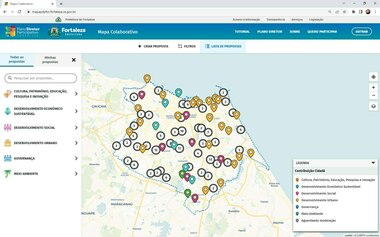
{"body":{"en":"<p>The Collaborative Digital Map platform of the Participatory Master Plan of Fortaleza was developed by the Fortaleza Planning Institute - IPLANFOR, in conjunction with the Department of Urban Planning and the Environment, the Department of Planning and the Department of Management, where all were involved in the definition process of needs. Its objective is to encourage the active participation of the population in the elaboration of the Participatory Master Plan of the city through an interactive digital map that allows the submission of georeferenced proposals. Users can submit their proposals and categorize them into 6 themes: Culture, Heritage, Education, Research and Innovation; Sustainable Economic Development; Social development; Urban Development; Governance; and Environment. Proposals are moderated by a responsible committee, which assesses their viability and relevance for the city. In addition, the platform allows the visualization of proposals submitted by other users, which encourages debate and the exchange of ideas among participants. Users can also \"like\" proposals that they find interesting and relevant. With this, the platform seeks to make the urban planning process more transparent and inclusive, involving the population in the decision-making process and ensuring that the needs and demands of citizens are considered in the preparation of the master plan.</p><div class=\"editor-content-image\" data-image=\"\"><img src=\"https://decidim-oidp.s3.amazonaws.com/uploads/decidim/decidim_awesome/editor_image/image/1094/BANNER_-_MAPA_COLABORATIVO_FORTALEZA.png\" alt=\"\"></div><p>The entire proposal submission process, as well as each moderation, is registered in the database with information that can be audited and that is also sent by email, to the author who is registered with the City Hall of Fortaleza, a necessary condition to make contributions.</p><p>We emphasize that the platform has a mechanism that allows its use in each review of the city's master plan, as well as that it can be expanded for use in other cities (provided that the base map is adapted), thus making it a wildcard platform for participatory projects of this type. Each database will be stored with a reference to a period (year of revision of the master plan).</p><div class=\"editor-content-image\" data-image=\"\"><img src=\"https://decidim-oidp.s3.amazonaws.com/uploads/decidim/decidim_awesome/editor_image/image/1093/DASH_-_MAPA_COLABORATIVO_FORTALEZA.jpg\" alt=\"\"></div><p><br></p><p><a href=\"https://mapapdpfor.fortaleza.ce.gov.br/\" target=\"_blank\">https://mapapdpfor.fortaleza.ce.gov.br/</a> </p><div class=\"editor-content-videoEmbed\" data-video-embed=\"https://www.youtube.com/embed/zCG7Qv7zUdo?showinfo=0\"><div><iframe src=\"https://www.youtube.com/embed/zCG7Qv7zUdo?showinfo=0\" title=\"\" frameborder=\"0\" allowfullscreen=\"true\"></iframe></div></div><p><br></p>","es":"<p>La plataforma del Mapa Digital Colaborativo del Plan Maestro Participativo de Fortaleza fue desarrollada por el Instituto de Planificación de Fortaleza - IPLANFOR, en conjunto con el Departamento de Planificación Urbana y Medio Ambiente, el Departamento de Planificación y el Departamento de Gestión, donde todos participaron en la proceso de definición de necesidades. Su objetivo es incentivar la participación activa de la población en la elaboración del Plan Director Participativo de la ciudad a través de un mapa digital interactivo que permite la presentación de propuestas georreferenciadas. Los usuarios pueden enviar sus propuestas y categorizarlas en 6 temas: Cultura, Patrimonio, Educación, Investigación e Innovación; Desarrollo Económico Sostenible; Desarrollo Social; Desarrollo Urbano; Gobernancia; y Medio Ambiente. Las propuestas son moderadas por un comité responsable, que evalúa su viabilidad y relevancia para la ciudad. Además, la plataforma permite la visualización de propuestas enviadas por otros usuarios, lo que fomenta el debate y el intercambio de ideas entre los participantes. Los usuarios también pueden dar \"me gusta\" a las propuestas que les parezcan interesantes y relevantes. Con esto, la plataforma busca hacer más transparente e inclusivo el proceso de planificación urbana, involucrando a la población en el proceso de toma de decisiones y asegurando que las necesidades y demandas de los ciudadanos sean consideradas en la elaboración del plan maestro.</p><div class=\"editor-content-image\" data-image=\"\"><img src=\"https://decidim-oidp.s3.amazonaws.com/uploads/decidim/decidim_awesome/editor_image/image/1095/BANNER_-_MAPA_COLABORATIVO_FORTALEZA.png\" alt=\"\"></div><p>Todo el proceso de envío de propuestas, así como cada moderación, se registra en la base de datos con información que puede ser auditada y que también se envía por correo electrónico, al autor que está registrado en el Ayuntamiento de Fortaleza, condición necesaria para hacer contribuciones. .</p><p>Destacamos que la plataforma cuenta con un mecanismo que permite su uso en cada revisión del plan maestro de la ciudad, así como que puede ampliarse para su uso en otras ciudades (siempre y cuando se adapte el mapa base), convirtiéndose así en una plataforma comodín. para proyectos participativos de este tipo Cada base de datos se almacenará con una referencia a un período (año de revisión del plan maestro).</p><div class=\"editor-content-image\" data-image=\"\"><img src=\"https://decidim-oidp.s3.amazonaws.com/uploads/decidim/decidim_awesome/editor_image/image/1096/DASH_-_MAPA_COLABORATIVO_FORTALEZA.jpg\" alt=\"\"></div><p><br></p><p><a href=\"https://mapapdpfor.fortaleza.ce.gov.br/\" target=\"_blank\">https://mapapdpfor.fortaleza.ce.gov.br/</a></p><div class=\"editor-content-videoEmbed\" data-video-embed=\"https://www.youtube.com/embed/zCG7Qv7zUdo?showinfo=0\"><div><iframe src=\"https://www.youtube.com/embed/zCG7Qv7zUdo?showinfo=0\" title=\"\" frameborder=\"0\" allowfullscreen=\"true\"></iframe></div></div><p><br></p>","fr":"<p>La plateforme Collaborative Digital Map du Schéma Directeur Participatif de Fortaleza a été développée par l'Institut d'Aménagement de Fortaleza - IPLANFOR, en collaboration avec le Département de l'Urbanisme et de l'Environnement, le Département de l'Aménagement et le Département de la Gestion, où tous ont été impliqués dans le processus de définition des besoins. Son objectif est d'encourager la participation active de la population à l'élaboration du Plan directeur participatif de la ville à travers une carte numérique interactive qui permet la soumission de propositions géoréférencées. Les utilisateurs peuvent soumettre leurs propositions et les classer en 6 thèmes : Culture, Patrimoine, Éducation, Recherche et Innovation ; développement économique durable ; Développement social; Développement urbain; Gouvernance ; et Environnement. Les propositions sont modérées par un comité responsable, qui évalue leur viabilité et leur pertinence pour la ville. De plus, la plateforme permet la visualisation des propositions soumises par d'autres utilisateurs, ce qui encourage le débat et l'échange d'idées entre les participants. Les utilisateurs peuvent également \"aimer\" les propositions qu'ils trouvent intéressantes et pertinentes. Ainsi, la plateforme cherche à rendre le processus de planification urbaine plus transparent et inclusif, en impliquant la population dans le processus de prise de décision et en veillant à ce que les besoins et les demandes des citoyens soient pris en compte dans la préparation du plan directeur.</p><div class=\"editor-content-image\" data-image=\"\"><img src=\"https://decidim-oidp.s3.amazonaws.com/uploads/decidim/decidim_awesome/editor_image/image/1091/BANNER_-_MAPA_COLABORATIVO_FORTALEZA.png\" alt=\"\"></div><p>L'ensemble du processus de soumission de proposition, ainsi que chaque modération, est enregistré dans la base de données avec des informations qui peuvent être auditées et qui sont également envoyées par courrier électronique, à l'auteur qui est enregistré auprès de la mairie de Fortaleza, condition nécessaire pour apporter des contributions. .</p><p>Nous soulignons que la plate-forme dispose d'un mécanisme qui permet son utilisation dans chaque révision du plan directeur de la ville, ainsi qu'elle peut être étendue pour une utilisation dans d'autres villes (à condition que la carte de base soit adaptée), ce qui en fait une plate-forme générique pour les projets participatifs de ce type Chaque base de données sera stockée avec une référence à une période (année de révision du schéma directeur).</p><div class=\"editor-content-image\" data-image=\"\"><img src=\"https://decidim-oidp.s3.amazonaws.com/uploads/decidim/decidim_awesome/editor_image/image/1092/DASH_-_MAPA_COLABORATIVO_FORTALEZA.jpg\" alt=\"\"></div><p><a href=\"https://mapapdpfor.fortaleza.ce.gov.br/ \" target=\"_blank\">https://mapapdpfor.fortaleza.ce.gov.br/ </a></p><div class=\"editor-content-videoEmbed\" data-video-embed=\"https://www.youtube.com/embed/zCG7Qv7zUdo?showinfo=0\"><div><iframe src=\"https://www.youtube.com/embed/zCG7Qv7zUdo?showinfo=0\" title=\"\" frameborder=\"0\" allowfullscreen=\"true\"></iframe></div></div><p><br></p>"},"title":{"en":"Fortaleza: Collaborative Digital Map of the Master Plan of Fortaleza","es":"Fortaleza: Mapa Digital Colaborativo del Plan Maestro de Fortaleza","fr":"Fortaleza : Carte numérique collaborative du plan directeur de Fortaleza"}}
This fingerprint is calculated using a SHA256 hashing algorithm. In order to replicate it yourself, you can use an MD5 calculator online and copy-paste the source data.


Share
Or copy link