The piece of text below is a shortened, hashed representation of this content. It is useful to ensure the content has not been tampered with, as a single modification would result in a totally different value.
Value:
d0bc29d43da8a53e8311cc1aafb03d240434f50dae3762cbbc199a58dffe8076
Source:
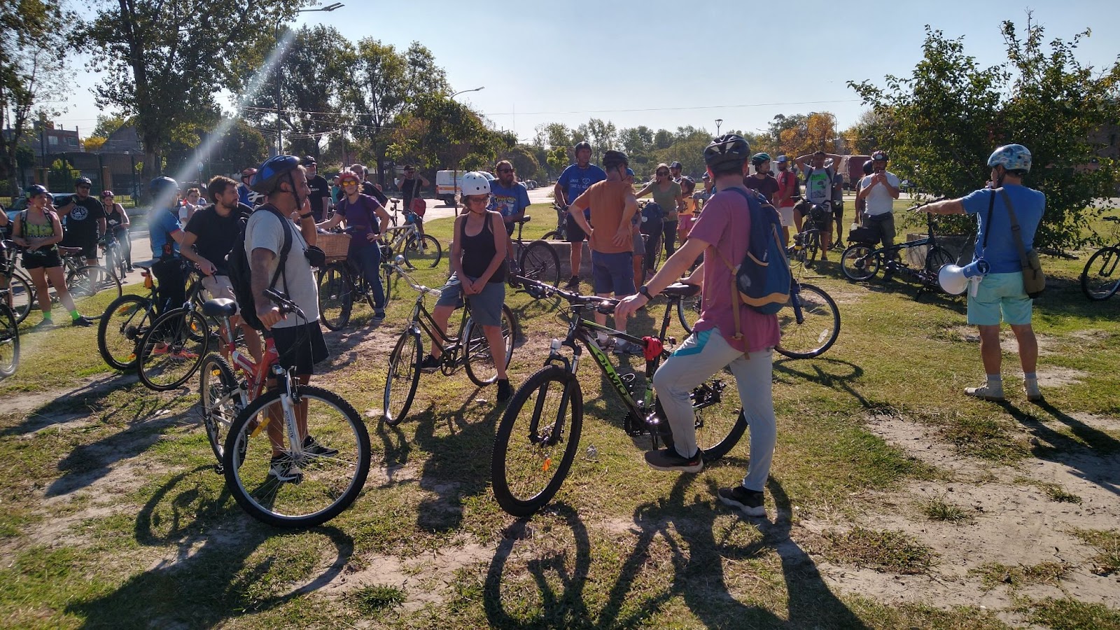
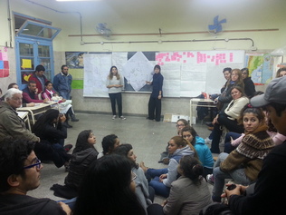
{"body":{"en":"<p>The Cildáñez Biocorridor consists of recovering the course of one of the most important streams in the Buenos Aires Metropolitan Area. Projects on a basin scale (Ex Mercado de Hacienda, Parque Avellaneda, Villa Cildáñez, Parque Indoamericano and Reserva Lago Lugano) are linked through <strong>a path of native plants and community gardens </strong>that form a system of green areas. </p><div class=\"editor-content-image\" data-image=\"\"><img src=\"https://lh7-us.googleusercontent.com/THm08o7sd1Rx5i6Gemtpq3WSV2-cBYcVjecgUmYPQOO6XDE0VnefCMrcJcpyS3WZHKGT3hNw6n_LyOp0f1KXsibWb5msnh8a_JiN1_TVwaNBODmll00EICxrdJobgM57LpkzQKCkYBapzI3XvAiZ1L0\" width=\"602\" alt=\"\"></div><p>The main innovation consists of having installed a <strong>basin </strong>scenario that transcends political boundaries and allows for inter-jurisdictional <strong>planning and management </strong>of the city, placing the r<strong>econstruction of the social fabric and the environmental fabric in direct relation to each other</strong>. The continuity of the <strong>PPGA methodology of Participatory Planning and Associated Management </strong>allowed for the promotion of a scenario of decision-making by consensus, building a technical-political-community network for an integral, intersectoral and multidisciplinary approach that gives life to a bio-cultural bio-corridor project, which recovers the historical and environmental memory of the territory. The achievements in terms of<strong> institutionalisation of the practices </strong>with the sanctioning of laws and inclusion in the government's organisational charts have become an unprecedented innovation in terms of recognition of <strong>participatory democracy </strong>that establishes the practice as a <strong>School-Project.</strong> </p><p>The project is the continuity of an experience that began at the end of the 80s, with the recovery of democracy after a terrible dictatorship and that has resulted in the recovery of Avellaneda Park, the second green and public space, its greatest expression. The founding milestone of the experience arose on April 2, 2013 after the tragic flood that left more than 100 dead in the Metropolitan Area of Buenos Aires. The Intercommunal Network of the Cildáñez Basin was immediately created to develop workshops implementing the Risk Map methodology, which made it possible to involve a large number of actors to carry out a diagnosis and develop a Programme for Before-During and After a future event, with recommendations for the formulation of public policies. The flood had its greatest impact in Villa Cildáñez, where the water reached a height of 1.5 metres. This is where the poorest population lives, on unregulated land and with poor housing and infrastructure. The population of the neighbourhood is very diverse, with an important socio-cultural richness from Argentina, Bolivia, Peru and Paraguay.</p><ul><li><p><a href=\"http://www.cuencaenred.com.ar\" rel=\"noopener noreferrer\" target=\"_blank\">www.cuencaenred.com.ar</a> </p></li></ul><p><br></p><p> </p>","es":"<p>El Biocorredor Cildáñez consiste en recuperar la traza de uno de los arroyos más importantes del Área Metropolitana de Buenos Aires. Se ponen en relación proyectos en escala de Cuenca (Ex Mercado de Hacienda, Parque Avellaneda, Villa Cildáñez, Parque Indoamericano y Reserva Lago Lugano) vinculándolos a través de <strong>un sendero de plantas nativas y huertas comunitarias</strong> que configure un sistema de áreas verdes. </p><div class=\"editor-content-image\" data-image=\"\"><img src=\"https://lh7-us.googleusercontent.com/THm08o7sd1Rx5i6Gemtpq3WSV2-cBYcVjecgUmYPQOO6XDE0VnefCMrcJcpyS3WZHKGT3hNw6n_LyOp0f1KXsibWb5msnh8a_JiN1_TVwaNBODmll00EICxrdJobgM57LpkzQKCkYBapzI3XvAiZ1L0\" width=\"602\" alt=\"\"></div><p>La innovación principal consiste en haber instalado un escenario de <strong>Cuenca </strong>que trasciende los límites políticos y permite <strong>planificar y gestionar</strong> la ciudad de forma interjurisdiccional, colocando en <strong>relación directa la reconstrucción del tejido social y el tejido ambiental. </strong></p><p>La continuidad del sostenimiento de la<strong> metodología PPGA de Planificación Participativa y Gestión Asociada</strong> permitió promover un escenario de toma de decisiones por consenso, construyendo una<strong> red técnica-política-comunitaria </strong>para un abordaje integral, intersectorial y multidisciplinario que da vida a un proyecto de Biocorredor bio-cultural, que recupera la memoria histórica y ambiental del territorio. Los logros en términos de<strong> institucionalización de las prácticas</strong> con la sanción de leyes e inclusión dentro de organigramas de gobierno se transforma en una innovación de reconocimiento de la <strong>democracia participativa</strong> sin precedentes que instala a la práctica como un <strong>Proyecto-Escuela. </strong></p><p>El Proyecto es continuidad de una experiencia que comienza a fines de los ´80, con la recuperación de la democracia posterior a una terrible dictadura y que tiene en la recuperación del Parque Avellaneda, el 2do espacio verde y público, su mayor expresión. El hito fundacional de la experiencia surge el día 2 de Abril del año 2013 después de la trágica inundación que dejó más de 100 muertos en el Área Metropolitana de Buenos Aires. Inmediatamente se crea la Red Intercomunal de la Cuenca Cildáñez para desarrollar los talleres implementando la metodología de Mapa de Riesgo, que permitió involucrar una gran cantidad de actores para realizar un diagnóstico y desarrollar un Programa para el Antes-Durante y Después de un futuro evento, con recomendaciones para la formulación de políticas públicas. La inundación tuvo su mayor impacto en Villa Cildáñez, donde el agua llegó a 1,5 m de altura. Allí vive la población más pobre, en tierras sin regularizar y con viviendas e infraestructura deficiente. La población del barrio es muy diversa, dando una importante riqueza socio cultural de Argentina, Bolivia, Perú y Paraguay.</p><ul><li><p><a href=\"http://www.cuencaenred.com.ar\" rel=\"noopener noreferrer\" target=\"_blank\">www.cuencaenred.com.ar</a> </p></li></ul><p> </p>","fr":"<p>Le biocorridor Cildáñez consiste à récupérer le cours de l'un des plus importants ruisseaux de la zone métropolitaine de Buenos Aires. Des projets à l'échelle du bassin (Ex Mercado de Hacienda, Parque Avellaneda, Villa Cildáñez, Parque Indoamericano et Reserva Lago Lugano) sont reliés par <strong>un chemin de plantes locales et de jardins communautaires </strong>qui forment un système d'espaces verts. </p><div class=\"editor-content-image\" data-image=\"\"><img src=\"https://lh7-us.googleusercontent.com/THm08o7sd1Rx5i6Gemtpq3WSV2-cBYcVjecgUmYPQOO6XDE0VnefCMrcJcpyS3WZHKGT3hNw6n_LyOp0f1KXsibWb5msnh8a_JiN1_TVwaNBODmll00EICxrdJobgM57LpkzQKCkYBapzI3XvAiZ1L0\" width=\"602\" alt=\"\"></div><p>La principale innovation consiste à mettre en place un scénario de <strong>bassin </strong>qui transcende les frontières politiques et permet une<strong> planification et une gestion </strong>inter-juridictionnelles de la ville, en plaçant <strong>la reconstruction du tissu social et du tissu environnemental en relation directe l'un avec l'autre</strong>. La continuité de la <strong>méthodologie PPGA de planification participative et de gestion associée</strong> a permis de promouvoir un scénario de prise de décision par consensus, en construisant un réseau technico-politico-communautaire pour une approche intégrale, intersectorielle et multidisciplinaire qui donne vie à un projet de bio-corridor culturel, qui récupère la mémoire historique et environnementale du territoire. Les réalisations en termes <strong>d'institutionnalisation des pratiques </strong>avec la sanction des lois et l'inclusion dans les organigrammes du gouvernement sont devenues une innovation sans précédent en termes de reconnaissance de la <strong>démocratie participative</strong> qui établit la pratique comme un <strong>projet d'école. </strong></p><p>Le projet est la continuité d'une expérience qui a commencé à la fin des années 80, avec la récupération de la démocratie après une terrible dictature, et qui a trouvé dans la récupération du parc Avellaneda, le deuxième espace vert et public, sa plus grande expression. L'étape fondatrice de l'expérience a eu lieu le 2 avril 2013 après la tragique inondation qui a fait plus de 100 morts dans la zone métropolitaine de Buenos Aires. Le Réseau Intercommunal du Bassin du Cildáñez a été immédiatement créé pour développer des ateliers mettant en œuvre la méthodologie de la Carte des Risques, qui a permis d'impliquer un grand nombre d'acteurs pour réaliser un diagnostic et développer un Programme pour Avant-Pendant et Après un futur événement, avec des recommandations pour la formulation de politiques publiques. L'inondation a eu le plus grand impact à Villa Cildáñez, où l'eau a atteint une hauteur de 1,5 mètre. C'est là que vit la population la plus pauvre, sur des terrains non réglementés, avec des logements et des infrastructures en mauvais état. La population du quartier est très diverse, avec une grande richesse socioculturelle provenant d'Argentine, de Bolivie, du Pérou et du Paraguay.</p><ul><li><p><a href=\"http://www.cuencaenred.com.ar\" rel=\"noopener noreferrer\" target=\"_blank\">www.cuencaenred.com.ar</a> </p></li></ul><p> </p>"},"title":{"en":"Buenos Aires: Cildáñez Biocorridor","es":"Buenos Aires: Biocorredor Cildáñez","fr":"Buenos Aires : Biocorridor Cildáñez"}}
This fingerprint is calculated using a SHA256 hashing algorithm. In order to replicate it yourself, you can use an MD5 calculator online and copy-paste the source data.


Share
Or copy link