The piece of text below is a shortened, hashed representation of this content. It is useful to ensure the content has not been tampered with, as a single modification would result in a totally different value.
Value:
3077bc6edbed779b2491d7c183624e66da2def50f0ff53fdd7d06ed485fc7efb
Source:
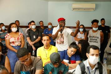
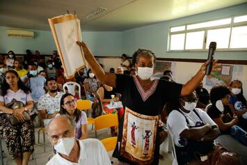
{"body":{"en":"<p>The <em>Ilha de Maré Plan</em> consisted of the participatory development of an integrated territorial development strategy for one of the main island and traditional territories of Salvador. Located in the “Bay of All Saints” (Bahia de Todos-os-Santos) and composed largely of Black and quilombola communities, the island has historically faced challenges related to access to public services, urban infrastructure, and development opportunities.</p><p>The initiative involved a broad process of community participation, with meetings and listening activities held across different areas of the island. This allowed residents, community leaders, and local organizations to directly contribute to the territorial diagnosis and to the definition of intervention priorities. Developed between 2021 and 2022, a period still marked by the impacts of the COVID-19 pandemic, the process required methodological adaptations to ensure the continuity of social participation and the sanitary safety of participants.</p><p>The implementation of the plan was carried out through a collaborative governance model that mobilized different municipal departments and institutional partners, integrating policies related to infrastructure, mobility, health, social assistance, and local development.</p><p>This approach not only aligned territorial demands with the broader guidelines of the municipal strategic planning framework—strengthening intersectoral coordination within public administration—but also resulted in the development of a structured plan organized around strategic axes and short-, medium-, and long-term objectives, guiding public investments and urban policies in the territory.</p><p>Among the results observed are improvements in urban infrastructure, expanded access to public services, and the implementation of new facilities and initiatives in the territory, directly benefiting around five thousand residents of the island. The initiative also strengthened dialogue between the municipal government and local communities, contributing to the institutionalization of citizen participation mechanisms in the region and in the implementation of public policies.</p><p>Beyond guiding concrete interventions, the experience consolidated a model of territorial planning oriented toward island territories and traditional communities, generating lessons that may inspire other cities interested in promoting more inclusive, resilient, and democratic urban development.</p><p>More information:<br><a href=\"https://geo.salvador.ba.gov.br/portal/apps/sites/#/salvador-dados/pages/planos-urbansticos-fmlf\"><u>https://geo.salvador.ba.gov.br/portal/apps/sites/#/salvador-dados/pages/planos-urbansticos-fmlf</u></a></p><p><a href=\"https://geo.salvador.ba.gov.br/portal/apps/sites/#/salvador-dados/pages/planos-urbansticos-fmlf\"><u>https://www.oidp.net/docs/repo/doc1910.pdf</u></a></p><p><br></p>","es":"<p>El <em>Plan de la Isla de Maré</em> consistió en la construcción participativa de una estrategia integrada de desarrollo territorial para uno de los principales territorios insulares y tradicionales de Salvador. Ubicada en la “Bahía de Todos los Santos” (Bahia de Todos-os-Santos) y formada por comunidades mayoritariamente negras y quilombolas, la isla ha enfrentado históricamente desafíos relacionados con el acceso a servicios públicos, infraestructura urbana y oportunidades de desarrollo.</p><p>La práctica implicó un amplio proceso de participación comunitaria, con reuniones y actividades de escucha realizadas en diversas localidades de la isla. Esto permitió que residentes, líderes comunitarios y organizaciones locales contribuyeran directamente al diagnóstico territorial y a la definición de prioridades de intervención. Desarrollado entre 2021 y 2022, período aún marcado por los impactos de la pandemia de COVID-19, el proceso requirió adaptaciones metodológicas para garantizar la continuidad de la participación social y la seguridad sanitaria de los participantes.</p><p>La implementación del plan se llevó a cabo mediante un modelo de gobernanza colaborativa que movilizó diferentes secretarías municipales y socios institucionales, integrando políticas de infraestructura, movilidad, salud, asistencia social y desarrollo local.</p><p>Este enfoque permitió no solo alinear las demandas territoriales con las directrices más amplias de la planificación estratégica municipal —fortaleciendo la coordinación intersectorial de la gestión pública— sino también consolidar la elaboración de un plan estructurado en ejes estratégicos y objetivos a corto, mediano y largo plazo, orientando las inversiones públicas y las políticas urbanas en el territorio.</p><p>Entre los resultados observados se encuentran mejoras en la infraestructura urbana, ampliación del acceso a servicios públicos y la implementación de nuevos equipamientos e iniciativas en el territorio, beneficiando directamente a cerca de cinco mil habitantes de la isla. Asimismo, se fortaleció el diálogo entre el gobierno municipal y las comunidades locales, contribuyendo a institucionalizar mecanismos de participación ciudadana en la región y en la implementación de políticas públicas.</p><p>Más allá de orientar intervenciones concretas, la experiencia consolidó una forma de planificación territorial orientada a territorios insulares y comunidades tradicionales, generando aprendizajes que pueden inspirar a otras ciudades interesadas en promover un desarrollo urbano más inclusivo, resiliente y democrático.</p><p>Más información:<br><a href=\"https://geo.salvador.ba.gov.br/portal/apps/sites/#/salvador-dados/pages/planos-urbansticos-fmlf\"><u>https://geo.salvador.ba.gov.br/portal/apps/sites/#/salvador-dados/pages/planos-urbansticos-fmlf</u></a></p><p><a href=\"https://geo.salvador.ba.gov.br/portal/apps/sites/#/salvador-dados/pages/planos-urbansticos-fmlf\"><u>https://www.oidp.net/docs/repo/doc1910.pdf</u></a></p><p><br></p>","fr":"<p>Le <em>Plan de l’Île de Maré</em> a consisté en la construction participative d’une stratégie intégrée de développement territorial pour l’un des principaux territoires insulaires et traditionnels de Salvador. Située dans la “Baie de Tous-les-Saints” (Bahia de Todos-os-Santos) et composée majoritairement de communautés noires et quilombolas, l’île a historiquement fait face à des défis liés à l’accès aux services publics, aux infrastructures urbaines et aux opportunités de développement.</p><p>L’initiative a impliqué un vaste processus de participation communautaire, avec des réunions et des activités d’écoute organisées dans les différentes localités de l’île. Cela a permis aux habitants, aux leaders communautaires et aux organisations locales de contribuer directement au diagnostic territorial et à la définition des priorités d’intervention. Développé entre 2021 et 2022, une période encore marquée par les impacts de la pandémie du COVID-19, le processus a nécessité des adaptations méthodologiques afin de garantir la continuité de la participation sociale et la sécurité sanitaire des participants.</p><p>La mise en œuvre du plan a été réalisée à travers un modèle de gouvernance collaborative mobilisant différentes secrétariats municipaux et partenaires institutionnels, intégrant des politiques d’infrastructure, de mobilité, de santé, d’assistance sociale et de développement local.</p><p>Cette approche a permis non seulement d’aligner les demandes territoriales sur les orientations plus larges de la planification stratégique municipale — renforçant la coordination intersectorielle de la gestion publique — mais aussi de consolider l’élaboration d’un plan structuré autour d’axes stratégiques et d’objectifs à court, moyen et long terme, orientant les investissements publics et les politiques urbaines dans le territoire.</p><p>Parmi les résultats observés figurent l’amélioration des infrastructures urbaines, l’élargissement de l’accès aux services publics et la mise en œuvre de nouveaux équipements et initiatives dans le territoire, bénéficiant directement à environ cinq mille habitants de l’île. L’initiative a également renforcé le dialogue entre la municipalité et les communautés locales, contribuant à institutionnaliser des mécanismes de participation citoyenne dans la région et dans la mise en œuvre des politiques publiques.</p><p>Au-delà de l’orientation d’interventions concrètes, l’expérience a consolidé un modèle de planification territoriale destiné aux territoires insulaires et aux communautés traditionnelles, produisant des enseignements susceptibles d’inspirer d’autres villes souhaitant promouvoir un développement urbain plus inclusif, résilient et démocratique.</p><p>Plus d’informations :<br><a href=\"https://geo.salvador.ba.gov.br/portal/apps/sites/#/salvador-dados/pages/planos-urbansticos-fmlf\"><u>https://geo.salvador.ba.gov.br/portal/apps/sites/#/salvador-dados/pages/planos-urbansticos-fmlf</u></a></p><p><a href=\"https://geo.salvador.ba.gov.br/portal/apps/sites/#/salvador-dados/pages/planos-urbansticos-fmlf\"><u>https://www.oidp.net/docs/repo/doc1910.pdf</u></a></p><p><br></p>"},"title":{"en":"Salvador: Ilha de Maré Plan","es":"Ilha de Maré: Plan de la Isla de Maré","fr":"Salvador : Plan de l’Île de Maré"}}
This fingerprint is calculated using a SHA256 hashing algorithm. In order to replicate it yourself, you can use an MD5 calculator online and copy-paste the source data.


Share
Or copy link